It all started a couple years ago when I learned about this rather long trail that conveniently starts (or finishes, depending on your perspective) about 20km North of the South Carolina house. I have ridden the trail somewhat regularly as there is a great 12+ minute singletrack climb that I use for hill repeats which is about a 40 minute ride from the house.
It's called the Foothills Trail and was built by the good folks at Duke Power (Nuke Plant) probably in a bid to offset the impact of the thousands of acres of forest land they flooded in the process of building the multiple power plants that exist in Northwest South Carolina. Politics aside what it means is that there is about 80 miles of trail which branches just North of the house all the way over to Caesar's Head.

For some reason I have found myself very motivated to explore this section of trail this spring but the problem is that it is a point to point. It is a very different experience riding this trail. There is a fair amount of hopping off the bike to march up or down steps since it is a hiking trail but if you take it in stride (no pun intended) then you can get a really good flow going and have an amazing experience.
Jerome and I drove out to Whitwater Falls a little over a week ago to explore the West section of the trail. We intended to ride out 2 hours and then back. I was hoping to meet up with a section of trail I had ridden before since I have ridden out 2 hours from the start of the trail a few times and it was good riding. If I could link it all up then it would make a great ride.

From the parking lot we could see that is was 28.3 miles, piece of cake. About 1.5 hours in we kept seeing regular mileage signs and the riding was good so we decided to leave the Teg at Whitewater and ride the trail all the way back to the house. Figured it would be about 3.5 hours to the West end of the trail which would be perfect because I only had 2 bottles. Then 40minutes back to the house from the end of the trail would make it just over 4 hours which was perfect.
Well we just kept riding and riding, looking for the section of trail I had ridden before which was about 1.5 hours from the end of our ride and mostly downhill. We rode, and rode, and rode some more but still the trail did not look familiar. Luckily we kept crossing some roads which had mileage signs telling us how far until the West end of the trail.
It was exciting and a little scary at the same time because we were pretty committed. At the same time we knew that we could bail at any time and take the highway home from the nearest road crossing. Ended up reaching the West side after about 5 hours of singletrack and then another 40 minutes on the road home meant that I had gone a looong way on 2 bottles. Luckily the temperature was very nice, about 18 degrees, and we had a tail wind on the road back to the house arriving just before dark. Wow what a great ride, was epic. From that point on I started planning our next leg of the trail.
With the West side of HWY 130 or Whitewater Falls conquered I set my sights on the much more ambitious section of trail that stretches from Whitewater Falls over to Rocky Bottom, or HWY 130 to HWY 178. I was trying to get as much information about this trail as possible. Luckily I found some great stuff on the ultra runner websites. Seems they have a race on this section of trail (although it turns out they cheat and skip a bunch of the trail by following an access road).
A few consistencies started appearing. Reports containing words like "epic", "mountainous", and even "gauntlet" to name a few. Needless to say I was getting nervous about the ride, even second guessing myself. I decided to go ahead with the planning. Jerome and I picked a day that fit in with our (his) training while still making sure it would not only be sunny on the day but sunny for a few days leading up to the ride to make sure the trail was dry.
We headed out at about 9am that morning after planning to leave for about 8am, perfect timing in my books. I had budgeted for this to take us up to 10 hours which meant we had to start riding at around 9am to be back safely before dark. We dropped the Teg off at the finish line, HWY 178 aka Rocky Bottom aka Laurel Valley then drove with the bikes in the Pulsar over to the start line at Whitewater Falls aka HWY 130. Jerome looked very optimistic at this point and not at all concerned about the hard interval ride he had done the day before. Perhaps he was much more oblivious to the magnitude of the task ahead of us than I.

We unloaded and geared up. I brought a pack with 3 bottles and some food as well as a bottle on the bike making 4 bottles (durr math). I planned on using a bottle every 2 hours. At each 2 hour interval I grabbed a quick snack and a new bottle. It was now 10:40am, almost 2 hours late, story of my life...

Below is the sign that marked the beginning of our trail. It was the only real information we had to go on. We knew if we headed down in this direction and followed the trail markers that eventually we would come out the other side, probably where we had parked the Teg. That was the great thing about it, the not knowing. I think it was had me addicted to exploring this trail. It wasn't about the training, or heart rate zones, or perceived exertion, it was about survival. It was a freeking adventure!

The trail markers were simple and effective. Small white rectangles painted on trees at regular intervals. We did come to a few intersections or open patches of campground where the direction of the Foothills Trail was not entirely clear, so we would look for the markers. Without fail there would always be an indicator of direction if you were of sound mind to be paying attention.

About 20 minutes into the ride it was not going well. In fact it was going just about how I had thought it would be going. It was rocky, steep, slow going. It was the Gauntlet! It took 5 minutes in our slippery cycling shoes just to navigate the boulders up to this bridge. One of the 2 dozen or so bridges we would encounter in this ride.

About an hour in things were actually now going very well. We had left behind the rocky river bank of Whitewater Falls and settled into some more cycling friendly terrain. Don't get me wrong, it was very mountainous and strenuous but most of it was ride-able which was more than I was expecting. At this point I felt very relieved and a sense of excitement. We might actually make it! And whats better we were experiencing one hell of an awesome trail.

It was steep on the way up, it was steep on the way down. The views were spectacular. The weather couldn't have been better. We kept a good rhythm even when encountering some of the rumoured 500 stairs on this segment of trail. We rode what we could and swung a leg off the bike to zip up (or down) parts not ride-able (or not smart to be ridden). We got pretty good at it and it all felt natural. Especially after our experience the week before with the Oconee section of trail, we developed a strategy to riding this type of trail.

Vegetation was fairly sparse near the peaks of the mountains and jungle-like at the bottoms of the valleys. Jerome kept hearing monkeys, I told him to keep drinking water.

We reached the Horse Pasture River and from a story on one of the Ultra Runner websites it seems it might have been around the halfway point. That was good news since we were 3 hours in. A 6 hour ride would be perfect though I think Jerome was starting to regret the intervals of the previous day. We started estimating ride times, Jerome said 5 hours 30 minutes, I said 5 hours 40 minutes.
Shortly thereafter we arrived in an open area with a few different directions (where they went I have no clue) and some mileage indicators. It had indicated to us that Whitewater falls was only something like 12 miles in the direction we had come from. Really?! 12 miles in 3 hours? That was not good. For the next 2 hours or so I would be doing the calculations in my head and convincing myself there was no way we were averaging 4 miles per hour. How could that be? The majority of the trail up to that point had been ride-able and at a pretty good pace. There was a fair amount of logging road were we had ticked away some good mileage.
Can you see the fear in our eyes in this photo? I think I was pretty nervous about our undertaking at this point but I knew that if the trail continued the way it had been for the first 3 hours then we would be fine, we were covering a decent amount of ground despite what the signs may be telling us.

As we slogged on the talking diminished and the initial excitement completely evaporated from my system. My saving grace was that Jerome was now a hurtin' unit so continuing at our pace was not hugely taxing for me.
Salvation! After just 4 hours of riding we reached the shore of Lake Jocassee. It was beautiful by the lake and we figured it must start flattening out soon. I had heard reports from the runners that the last 8 miles was super easy and flat. We were looking forward to that.

The sign at the lake informed us we had something like 15 miles to go. Piece of cake. I grabbed my 3rd bottle and had a quick bite to eat. We were off with renewed optimism. I figured maybe one more mountain then flat open pastures with snaking singletrack.

A few miles down the trail we crossed over the Northern tip of Lake Jocassee on this huge swing bridge. It was an awesome sight to behold in the middle of nowhere. What an epic ride!

It has some nice swing to it. Like a carnival ride. Was high up too, didn't realise until I was about 1/2 way across. Probably over 100 feet off the ground.

Well if we only had one more mountain to climb did they ever make it count. Holy crap talk about the Gauntlet! A couple hundred stairs met us on the other side of the bridge, some so steep it was pretty much a ladder propped on the side of the mountain. What little upper body strength I posses was definitely put to the test here. You know it's serious if I actually have to stop for a few seconds to catch my breath. Jerome soldiered on and I snapped a pic at the very top of what had to be 20 minutes of stairs. We descended almost as quickly as we climbed to the top. Although luckily most of it was ride-able so it was a nice break. The brakes were smoking by the bottom for probably the dozenth time by now. We were greeted at the bottom by yet another mountain climb, I guess we were a little hasty in our celebration.

Minutes turned to hours, the trail continued around the next bend, over the next mountain, down the next fire road, by the next campsite, again and again. We were now at survival pace, a pace we could maintain for possibly many more hours to come. We were waiting for this easy 8 mile stretch, where was it?
We were now legends in our own minds. The subjects of exaggerated campfire stories for all those hikers passed.
"hey did you see those mountain bikers out on the trail? I heard they rode the whole trail in one day and were 10 feet tall and were from a galaxy far far away!"
It's funny how everyone thinks they are exceptional in their act of conquering this trail.
"How long you guys been at it?"
"4 days, we're doing the whole trail"
Somehow each hiker we encountered seemed dissatisfied at the realisation that hey, everyone on this trail is experiencing an epic adventure. All egos are equal out here.
Up another climb and around the bend we came upon a really cool waterfall. Was a much bigger drop then the camera gives it credit for. Not sure if Jerome was impressed, I think this picture illustrates his thought process of trying to decide whether or not I was consumable.

After another mountain climb from hell, this one entirely ride-able but incomprehensibly steep and long, we started criss-crossing along a gravely road. The trail crossed it a few times and I knew we must be getting closer to the Laurel Valley parking lot. And just as suddenly as we had entered the wilderness, it conceded. There was no easy 8 mile stretch, those runners were on meth.
The end was instantaneous and glorious. It was just trail, trail, trail, trail, BAM civilization. 6 hours and 40 minutes ridden. 6000 feet of climbing. Probably around 55-60km.
We could finally relax, we had ridden the trail. That was it, we started in one place and made it to another. Simple, the way cycling should be.
Jerome "dude show me on the map where we started"
Me "uh it's not actually on the map"
Jerome "oh shit"
For the photo I got him to place his left hand approximately where we had begun our adventure and his right hand at the finish.

Crack the wine Jerome. We made it alive!

I have that "I just rode a long freeking way and now I am gonna eat all the junk food I can get my hands on" look on my face. We loaded up the Teg and drove back over to pick up the Pulsar, all the time reveling as we glanced to the North realising that we had conquered that area of mountainous wilderness.

There she was, looking fine. Was funny to think back to the morning when we had set out. Seemed like it had happened on a different day then when we finished. We drove back to the house for pizza and beer and I went back to figuring out where to explore next.

This was pretty well the only map I had to go by. From the SC 130 and West is the Oconee section of trail. To the West of SC 130 and to US 178 is the Laurel Valley section. Where section 5 ends and 6 begins is where we hit Lake Jocassee with the huge suspension bridge.


 The trail markers were simple and effective. Small white rectangles painted on trees at regular intervals. We did come to a few intersections or open patches of campground where the direction of the Foothills Trail was not entirely clear, so we would look for the markers. Without fail there would always be an indicator of direction if you were of sound mind to be paying attention.
 About 20 minutes into the ride it was not going well. In fact it was going just about how I had thought it would be going. It was rocky, steep, slow going. It was the Gauntlet! It took 5 minutes in our slippery cycling shoes just to navigate the boulders up to this bridge. One of the 2 dozen or so bridges we would encounter in this ride.
 About an hour in things were actually now going very well. We had left behind the rocky river bank of Whitewater Falls and settled into some more cycling friendly terrain. Don't get me wrong, it was very mountainous and strenuous but most of it was ride-able which was more than I was expecting. At this point I felt very relieved and a sense of excitement. We might actually make it! And whats better we were experiencing one hell of an awesome trail.
 It was steep on the way up, it was steep on the way down. The views were spectacular. The weather couldn't have been better. We kept a good rhythm even when encountering some of the rumoured 500 stairs on this segment of trail. We rode what we could and swung a leg off the bike to zip up (or down) parts not ride-able (or not smart to be ridden). We got pretty good at it and it all felt natural. Especially after our experience the week before with the Oconee section of trail, we developed a strategy to riding this type of trail.
 Vegetation was fairly sparse near the peaks of the mountains and jungle-like at the bottoms of the valleys. Jerome kept hearing monkeys, I told him to keep drinking water.
 We reached the Horse Pasture River and from a story on one of the Ultra Runner websites it seems it might have been around the halfway point. That was good news since we were 3 hours in. A 6 hour ride would be perfect though I think Jerome was starting to regret the intervals of the previous day. We started estimating ride times, Jerome said 5 hours 30 minutes, I said 5 hours 40 minutes.
 As we slogged on the talking diminished and the initial excitement completely evaporated from my system. My saving grace was that Jerome was now a hurtin' unit so continuing at our pace was not hugely taxing for me.
 The sign at the lake informed us we had something like 15 miles to go. Piece of cake. I grabbed my 3rd bottle and had a quick bite to eat. We were off with renewed optimism. I figured maybe one more mountain then flat open pastures with snaking singletrack.
 A few miles down the trail we crossed over the Northern tip of Lake Jocassee on this huge swing bridge. It was an awesome sight to behold in the middle of nowhere. What an epic ride!
 It has some nice swing to it. Like a carnival ride. Was high up too, didn't realise until I was about 1/2 way across. Probably over 100 feet off the ground.
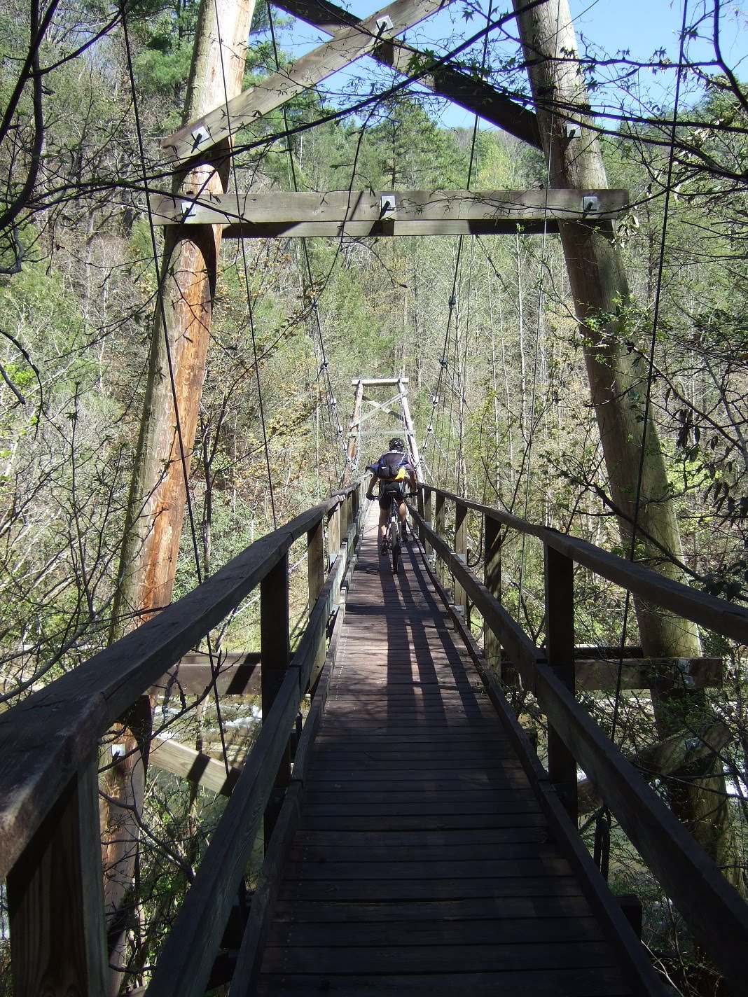 Well if we only had one more mountain to climb did they ever make it count. Holy crap talk about the Gauntlet! A couple hundred stairs met us on the other side of the bridge, some so steep it was pretty much a ladder propped on the side of the mountain. What little upper body strength I posses was definitely put to the test here. You know it's serious if I actually have to stop for a few seconds to catch my breath. Jerome soldiered on and I snapped a pic at the very top of what had to be 20 minutes of stairs. We descended almost as quickly as we climbed to the top. Although luckily most of it was ride-able so it was a nice break. The brakes were smoking by the bottom for probably the dozenth time by now. We were greeted at the bottom by yet another mountain climb, I guess we were a little hasty in our celebration.
 Minutes turned to hours, the trail continued around the next bend, over the next mountain, down the next fire road, by the next campsite, again and again. We were now at survival pace, a pace we could maintain for possibly many more hours to come. We were waiting for this easy 8 mile stretch, where was it?
 After another mountain climb from hell, this one entirely ride-able but incomprehensibly steep and long, we started criss-crossing along a gravely road. The trail crossed it a few times and I knew we must be getting closer to the Laurel Valley parking lot. And just as suddenly as we had entered the wilderness, it conceded. There was no easy 8 mile stretch, those runners were on meth.
 Crack the wine Jerome. We made it alive!
 I have that "I just rode a long freeking way and now I am gonna eat all the junk food I can get my hands on" look on my face. We loaded up the Teg and drove back over to pick up the Pulsar, all the time reveling as we glanced to the North realising that we had conquered that area of mountainous wilderness.
 There she was, looking fine. Was funny to think back to the morning when we had set out. Seemed like it had happened on a different day then when we finished. We drove back to the house for pizza and beer and I went back to figuring out where to explore next.
 This was pretty well the only map I had to go by. From the SC 130 and West is the Oconee section of trail. To the West of SC 130 and to US 178 is the Laurel Valley section. Where section 5 ends and 6 begins is where we hit Lake Jocassee with the huge suspension bridge.